Search results

Search Results
Displaying (601 - 620 of 620)
Pages

- Title
- Seymour Arm British Columbia NTS (National Topographic Survey) 82 / M
- Date
- 1974
- Is Part of
- Revelstoke Museum & Archives Maps, Plans & Drawings
- Source
- Revelstoke Museum & Archives
- Local Identifer
- A2016.216.000
- PID
- revelstoke:26543
- Title
- Glacier National Park plan of Lower Nakimu Caves
- Date
- 1959
- Is Part of
- Revelstoke Museum & Archives Maps, Plans & Drawings
- Source
- Revelstoke Museum & Archives
- Local Identifer
- A2016.327.003
- PID
- revelstoke:26551

- Title
- Plan 9504 A 18 Plan of the Town of Revelstoke being part of Sec 34, Twp 23, Rge 2, W6th I.M.
- Date
- 1965
- Is Part of
- Revelstoke Museum & Archives Maps, Plans & Drawings
- Source
- Revelstoke Museum & Archives
- Local Identifer
- A2016.330.000
- PID
- revelstoke:26552
- Title
- Kootenay Osoyoos & Similkameen
- Date
- 1930
- Is Part of
- Revelstoke Museum & Archives Maps, Plans & Drawings
- Source
- Revelstoke Museum & Archives
- Local Identifer
- A1971.002.005
- PID
- revelstoke:26230

- Title
- Aerial photographs of Revelstoke
- Date
- 1965
- Is Part of
- Revelstoke Museum & Archives Maps, Plans & Drawings
- Source
- Revelstoke Museum & Archives
- Local Identifer
- A2002.004.015
- PID
- revelstoke:26233

- Title
- Plans for Imperial Bank of Canada, Revelstoke, B.C.
- Date
- 1902
- Is Part of
- Revelstoke Museum & Archives Maps, Plans & Drawings
- Source
- Revelstoke Museum & Archives
- Local Identifer
- A2002.004.026
- PID
- revelstoke:26240

- Title
- Insurance plan of Revelstoke, B.C.
- Date
- 1955
- Is Part of
- Revelstoke Museum & Archives Maps, Plans & Drawings
- Source
- Revelstoke Museum & Archives
- Local Identifer
- A2004.028.000
- PID
- revelstoke:26257

- Title
- Insurance map of Revelstoke in 13 sections
- Date
- 1905
- Is Part of
- Revelstoke Museum & Archives Maps, Plans & Drawings
- Source
- Revelstoke Museum & Archives
- Local Identifer
- A2004.028.001
- PID
- revelstoke:26272

- Title
- Fire insurance map of Revelstoke with multiple revisions
- Date
- 1932-1948
- Is Part of
- Revelstoke Museum & Archives Maps, Plans & Drawings
- Source
- Revelstoke Museum & Archives
- Local Identifer
- A2004.028.002
- PID
- revelstoke:26285

- Title
- Plans for restoration of Revelstoke Courthouse
- Date
- 1974-1977
- Is Part of
- Revelstoke Museum & Archives Maps, Plans & Drawings
- Source
- Revelstoke Museum & Archives
- Local Identifer
- A2004.077.000
- PID
- revelstoke:26292

- Title
- Plans of Courthouse at Revelstoke
- Date
- 1910-1911
- Is Part of
- Revelstoke Museum & Archives Maps, Plans & Drawings
- Source
- Revelstoke Museum & Archives
- Local Identifer
- A2004.077.001
- PID
- revelstoke:26305

- Title
- Riparian-zone Technical Maps of Columbia River Valley
- Date
- 1951-1958
- Is Part of
- Revelstoke Museum & Archives Maps, Plans & Drawings
- Source
- Revelstoke Museum & Archives
- Local Identifer
- A2004.078.000
- PID
- revelstoke:26312

- Title
- City of Revelstoke official Cadastral Atlas
- Date
- 2000
- Is Part of
- Revelstoke Museum & Archives Maps, Plans & Drawings
- Source
- Revelstoke Museum & Archives
- Local Identifer
- A2016.084.000
- PID
- revelstoke:26315

- Title
- Revelstoke Composite Maps C82 Series Nelson Land Registration District, Kootenay Land District
- Date
- 1962-1967
- Is Part of
- Revelstoke Museum & Archives Maps, Plans & Drawings
- Source
- Revelstoke Museum & Archives
- Local Identifer
- A2016.097.000
- PID
- revelstoke:26320
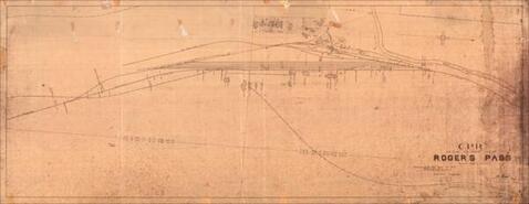
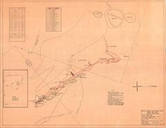
- Title
- C.P.R. British Columbia Division, Roger's Pass plan
- Date
- 1912-1915
- Is Part of
- Revelstoke Museum & Archives Maps, Plans & Drawings
- Source
- Revelstoke Museum & Archives
- Local Identifer
- A1962.037.000
- PID
- revelstoke:26321

- Title
- Plan of William Abrahamson's addition to Trout Lake City
- Date
- ca. 1900
- Is Part of
- Revelstoke Museum & Archives Maps, Plans & Drawings
- Source
- Revelstoke Museum & Archives
- Local Identifer
- A1985.030.007
- PID
- revelstoke:26332

- Title
- City of Revelstoke City Centre West
- Date
- 1966
- Is Part of
- Revelstoke Museum & Archives Maps, Plans & Drawings
- Source
- Revelstoke Museum & Archives
- Local Identifer
- A2002.004.030
- PID
- revelstoke:26379

- Title
- Public Works of Canada Site of Wharf at Arrowhead, BC
- Date
- 1953
- Is Part of
- Revelstoke Museum & Archives Maps, Plans & Drawings
- Source
- Revelstoke Museum & Archives
- Local Identifer
- A2011.022.009
- PID
- revelstoke:26412
- Title
- Revelstoke Electoral District map 3
- Date
- 1938
- Is Part of
- Revelstoke Museum & Archives Maps, Plans & Drawings
- Source
- Revelstoke Museum & Archives
- Local Identifer
- A2016.081.002
- PID
- revelstoke:26424

- Title
- Mount Revelstoke British Columbia Map 82 M/1
- Date
- 1975
- Is Part of
- Revelstoke Museum & Archives Maps, Plans & Drawings
- Source
- Revelstoke Museum & Archives
- Local Identifer
- A2016.211.003
- PID
- revelstoke:26528