Search results

Search Results
Displaying (1 - 20 of 105)
Pages

- Title
- Revelstoke, British Columbia, West of Sixth Meridian
- Date
- 1931
- Is Part of
- Enderby and District Museum and Archives Map Collection
- Source
- Enderby and District Museum and Archives
- Local Identifer
- 1.004
- PID
- enderby:776

- Title
- Revelstoke, British Columbia, West of Sixth Meridian
- Date
- 1965
- Is Part of
- Enderby and District Museum and Archives Map Collection
- Source
- Enderby and District Museum and Archives
- Local Identifer
- 1.005
- PID
- enderby:777

- Title
- Profile of Mount Revelstoke Motor Road
- Date
- ca. 1923
- Is Part of
- Revelstoke Museum & Archives Maps, Plans & Drawings
- Source
- Revelstoke Museum & Archives
- Local Identifer
- A2002.003.003
- PID
- revelstoke:26351

- Title
- Topographical Map of Selkirk Mountains
- Date
- ca. 1900
- Is Part of
- Revelstoke Museum & Archives Maps, Plans & Drawings
- Source
- Revelstoke Museum & Archives
- Local Identifer
- A1988.029.000
- PID
- revelstoke:26348

- Title
- Plan of Mount Revelstoke Motor Road (Plan 'A')
- Date
- ca. 1923
- Is Part of
- Revelstoke Museum & Archives Maps, Plans & Drawings
- Source
- Revelstoke Museum & Archives
- Local Identifer
- A2002.003.001
- PID
- revelstoke:26349

- Title
- Map of Mount Revelstoke National Park
- Date
- 1923
- Is Part of
- Revelstoke Museum & Archives Maps, Plans & Drawings
- Source
- Revelstoke Museum & Archives
- Local Identifer
- A2002.003.004
- PID
- revelstoke:26352

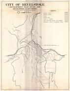
- Title
- City of Revelstoke official zoning map
- Date
- 1980
- Is Part of
- Revelstoke Museum & Archives Maps, Plans & Drawings
- Source
- Revelstoke Museum & Archives
- Local Identifer
- A2002.004.000
- PID
- revelstoke:26353
- Title
- Plan of Revelstoke and environs, Revelstoke Development Plan
- Date
- 1966
- Is Part of
- Revelstoke Museum & Archives Maps, Plans & Drawings
- Source
- Revelstoke Museum & Archives
- Local Identifer
- A2002.004.005
- PID
- revelstoke:26358

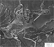
- Title
- Aerial photograph of Revelstoke townsite
- Date
- 1977
- Is Part of
- Revelstoke Museum & Archives Maps, Plans & Drawings
- Source
- Revelstoke Museum & Archives
- Local Identifer
- A2002.004.004
- PID
- revelstoke:26357

- Title
- Aerial blueprint of Revelstoke hydro dam near completion
- Date
- 1983
- Is Part of
- Revelstoke Museum & Archives Maps, Plans & Drawings
- Source
- Revelstoke Museum & Archives
- Local Identifer
- A2002.004.003
- PID
- revelstoke:26356
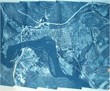
- Title
- Aerial photograph of Revelstoke dam and city
- Date
- 1978
- Is Part of
- Revelstoke Museum & Archives Maps, Plans & Drawings
- Source
- Revelstoke Museum & Archives
- Local Identifer
- A2002.004.002
- PID
- revelstoke:26355
- Title
- Aerial blueprint of Revelstoke area with elevation contours
- Date
- ca. 1960
- Is Part of
- Revelstoke Museum & Archives Maps, Plans & Drawings
- Source
- Revelstoke Museum & Archives
- Local Identifer
- A2002.004.001
- PID
- revelstoke:26354

- Title
- Plan of Mount Revelstoke Motor Road (Plan 'B')
- Date
- 1923
- Is Part of
- Revelstoke Museum & Archives Maps, Plans & Drawings
- Source
- Revelstoke Museum & Archives
- Local Identifer
- A2002.003.002
- PID
- revelstoke:26350

- Title
- Aerial photograph of area North of Revelstoke, Revelstoke Dam project construction site
- Date
- 1977
- Is Part of
- Revelstoke Museum & Archives Maps, Plans & Drawings
- Source
- Revelstoke Museum & Archives
- Local Identifer
- A2002.004.020
- PID
- revelstoke:26372

- Title
- Draft zoning map of Big Eddy area
- Date
- 1976
- Is Part of
- Revelstoke Museum & Archives Maps, Plans & Drawings
- Source
- Revelstoke Museum & Archives
- Local Identifer
- A2002.004.021
- PID
- revelstoke:26373

- Title
- Land use map, City of Revelstoke, Official Community Plan
- Date
- 1979
- Is Part of
- Revelstoke Museum & Archives Maps, Plans & Drawings
- Source
- Revelstoke Museum & Archives
- Local Identifer
- A2002.004.019
- PID
- revelstoke:26371

- Title
- Aerial photograph - Plan of Big Eddy Area, Revelstoke - Special Mosaic relating to Columbia River Developments
- Date
- 1960
- Is Part of
- Revelstoke Museum & Archives Maps, Plans & Drawings
- Source
- Revelstoke Museum & Archives
- Local Identifer
- A2002.004.012
- PID
- revelstoke:26365

- Title
- Plan of Exploration at Revelstoke-Arrow Project - Revelstoke Land Protection
- Date
- 1965
- Is Part of
- Revelstoke Museum & Archives Maps, Plans & Drawings
- Source
- Revelstoke Museum & Archives
- Local Identifer
- A2002.004.013
- PID
- revelstoke:26366

- Title
- Land use map of Revelstoke, residential accommodation, Revelstoke Development
- Date
- 1966
- Is Part of
- Revelstoke Museum & Archives Maps, Plans & Drawings
- Source
- Revelstoke Museum & Archives
- Local Identifer
- A2002.004.007
- PID
- revelstoke:26360

- Title
- Aerial photograph of Revelstoke area with prominent features labelled
- Date
- 1979
- Is Part of
- Revelstoke Museum & Archives Maps, Plans & Drawings
- Source
- Revelstoke Museum & Archives
- Local Identifer
- A2002.004.010
- PID
- revelstoke:26363