Jump to navigation
Home
Browse
About
Contact Us
Navigating & Searching
Partner Information
Login
Search Term
Advanced Search
You are here
Home
›
Mining
(x)
›
map
(x)
›
Search results
Search results
Search Results
Displaying (41 - 60 of 120)
Pages
« first
‹ previous
1
2
3
4
5
next ›
last »
Title
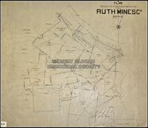
Plan showing the property of Ruth Mines Company
Date
1895
Is Part of
Silvery Slocan Historical Society Map Collection
Source
Silvery Slocan Historical Society
Local Identifer
6.21
PID
sshs:2416
Title
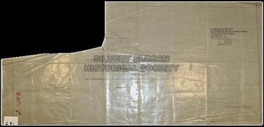
Rough plan of workings on Silver Band Mine
Date
1900
Is Part of
Silvery Slocan Historical Society Map Collection
Source
Silvery Slocan Historical Society
Local Identifer
6.22
PID
sshs:2417
Title
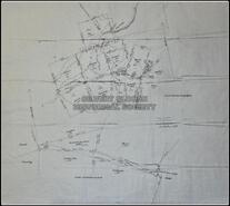
Pengelly Mines Ltd., Silver Ridge project, Sandon BC survey grid and claim location map
Date
1893
Is Part of
Silvery Slocan Historical Society Map Collection
Source
Silvery Slocan Historical Society
Local Identifer
6.23
PID
sshs:2418
Title
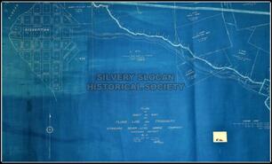
Surface Plan of the Northeast Slopes of the Silver Ridge - Sandon BC. Showing the projection of the Ruth-Victor Structure and its spatial relationship to the Known Parallel Lode System.
Date
1959
Is Part of
Silvery Slocan Historical Society Map Collection
Source
Silvery Slocan Historical Society
Local Identifer
6.24
PID
sshs:2419
Title
Silversmith, Slocan Star, Rabbit Paw claims
Date
n.d.
Is Part of
Silvery Slocan Historical Society Map Collection
Source
Silvery Slocan Historical Society
Local Identifer
6.25
PID
sshs:2420
Title
Plan of Slocan Star and Slocan King Mines
Date
1900
Is Part of
Silvery Slocan Historical Society Map Collection
Source
Silvery Slocan Historical Society
Local Identifer
6.26
PID
sshs:2421
Title
Twilight group, plan showing underground workings
Date
1915
Is Part of
Silvery Slocan Historical Society Map Collection
Source
Silvery Slocan Historical Society
Local Identifer
6.27
PID
sshs:2422
Title
Twilight group of mineral claims
Date
1915
Is Part of
Silvery Slocan Historical Society Map Collection
Source
Silvery Slocan Historical Society
Local Identifer
6.28
PID
sshs:2423
Title
Viola Mac Mines Ltd., New Denver BC. Plan showing the relationship between the new (1961) SBM adit and the adjoining properties.
Date
1961
Is Part of
Silvery Slocan Historical Society Map Collection
Source
Silvery Slocan Historical Society
Local Identifer
6.29
PID
sshs:2424
Title
To accompany report on the Washington Slocan Boy Mines
Date
1898
Is Part of
Silvery Slocan Historical Society Map Collection
Source
Silvery Slocan Historical Society
Local Identifer
6.3
PID
sshs:2425
Title
Longitudinal section of the working of the Washington and Slocan Boy mines
Date
1899
Is Part of
Silvery Slocan Historical Society Map Collection
Source
Silvery Slocan Historical Society
Local Identifer
6.31
PID
sshs:2426
Title
Plan underground workings Washington Mine
Date
1899
Is Part of
Silvery Slocan Historical Society Map Collection
Source
Silvery Slocan Historical Society
Local Identifer
6.32
PID
sshs:2427
Title
CPR mining map
Date
1895
Is Part of
Silvery Slocan Historical Society Map Collection
Source
Silvery Slocan Historical Society
Local Identifer
4.42
PID
sshs:2444
Title
Map of the Slocan mining camp
Date
1917
Is Part of
Silvery Slocan Historical Society Map Collection
Source
Silvery Slocan Historical Society
Local Identifer
4.43
PID
sshs:2445
Title
Sketch map of the Slocan Lake District
Date
ca. 1897
Is Part of
Silvery Slocan Historical Society Map Collection
Source
Silvery Slocan Historical Society
Local Identifer
4.6
PID
sshs:2447
Title
Lucky Jim and surrounding claims in Zincton area.
Date
1896
Is Part of
Silvery Slocan Historical Society Map Collection
Source
Silvery Slocan Historical Society
Local Identifer
4.7
PID
sshs:2448
Title
Slocan mining camp
Date
1897
Is Part of
Silvery Slocan Historical Society Map Collection
Source
Silvery Slocan Historical Society
Local Identifer
4.8
PID
sshs:2449
Title
Plan of right-of-way for flume & tramway of Standard Silvers Lead Mining Co.
Date
1913
Is Part of
Silvery Slocan Historical Society Map Collection
Source
Silvery Slocan Historical Society
Local Identifer
5.12
PID
sshs:2450
Title
Santiago Mines Ltd., Bosun Mine, New Denver
Date
1957
Is Part of
Silvery Slocan Historical Society Map Collection
Source
Silvery Slocan Historical Society
Local Identifer
6.3
PID
sshs:2457
Title
Plan and section of Slocan Boy and Washington Mines
Date
1898
Is Part of
Silvery Slocan Historical Society Map Collection
Source
Silvery Slocan Historical Society
Local Identifer
6.34
PID
sshs:2458
Pages
« first
‹ previous
1
2
3
4
5
next ›
last »