Jump to navigation
Home
Browse
About
Contact Us
Navigating & Searching
Partner Information
Login
Search Term
Advanced Search
You are here
Home
›
Mining
(x)
›
photograph
(x)
›
Search results
Search results
Search Results
Displaying (81 - 100 of 155)
Pages
« first
‹ previous
…
3
4
5
6
7
next ›
last »
Title
Plan showing portals of LH Mine tunnels and outcrops on west side of creek, Map 5A
Date
1942
Is Part of
Silvery Slocan Historical Society Map Collection
Source
Silvery Slocan Historical Society
Local Identifer
6.51
PID
sshs:2521
Title
Plan showing portals of LH Mine tunnels and outcrops on west side of creek, Map 5A
Date
1942
Is Part of
Silvery Slocan Historical Society Map Collection
Source
Silvery Slocan Historical Society
Local Identifer
6.52
PID
sshs:2522
Title
LH Mine Map 4
Date
ca. 1900
Is Part of
Silvery Slocan Historical Society Map Collection
Source
Silvery Slocan Historical Society
Local Identifer
6.53
PID
sshs:2523
Title
Plan of MacAllister Mine, Slocan BC
Date
n.d.
Is Part of
Silvery Slocan Historical Society Map Collection
Source
Silvery Slocan Historical Society
Local Identifer
6.56
PID
sshs:2526
Title
McAllister Mine, longitudinal projection, looking northwest
Date
1935
Is Part of
Silvery Slocan Historical Society Map Collection
Source
Silvery Slocan Historical Society
Local Identifer
6.57
PID
sshs:2527
Title
McAllister Mine Assay Plan of No. 2 tunnel
Date
1935
Is Part of
Silvery Slocan Historical Society Map Collection
Source
Silvery Slocan Historical Society
Local Identifer
6.58
PID
sshs:2528
Title
McAllister Mine Assay Plan of No. 3 tunnel
Date
1935
Is Part of
Silvery Slocan Historical Society Map Collection
Source
Silvery Slocan Historical Society
Local Identifer
6.59
PID
sshs:2529
Title
McAllister Mine Assay Plan of No. 5 level
Date
1935
Is Part of
Silvery Slocan Historical Society Map Collection
Source
Silvery Slocan Historical Society
Local Identifer
6.61
PID
sshs:2530
Title
McAllister Mine No. 6 level
Date
1935
Is Part of
Silvery Slocan Historical Society Map Collection
Source
Silvery Slocan Historical Society
Local Identifer
6.62
PID
sshs:2531
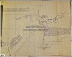
Title
[Western Exploration Co. Mammoth Mill plans]
Date
1929
Is Part of
Silver Slocan Historical Society Map Collection
Source
Silvery Slocan Historical Society
Local Identifer
16.4
PID
sshs:2514
Title
Sketch of the Enterprise Group and adjacent claims, Slocan Division, West Kootenay District
Date
1898
Is Part of
Silvery Slocan Historical Society Map Collection
Source
Silvery Slocan Historical Society
Local Identifer
6.4
PID
sshs:2517
Title
Plan of LH Mine Map 4
Date
1937
Is Part of
Silvery Slocan Historical Society Map Collection
Source
Silvery Slocan Historical Society
Local Identifer
6.49
PID
sshs:2518
Title
Plan showing part of underground workings, enterprises Mine, Slocan Mining Division, B.C
Date
1931
Is Part of
Silvery Slocan Historical Society Map Collection
Source
Silvery Slocan Historical Society
Local Identifer
6.5
PID
sshs:2519
Title
Sketch map of Slocan Lake, 21 June, 1895
Date
1895
Is Part of
Silvery Slocan Historical Society Map Collection
Source
Silvery Slocan Historical Society
Local Identifer
4.2
PID
sshs:2533
Title
Slocan and Ainsworth mining claims
Date
1970
Is Part of
Silvery Slocan Historical Society Map Collection
Source
Silvery Slocan Historical Society
Local Identifer
4.28
PID
sshs:2534
Title
Geological plan: Silverton Area Slocan Mining Camp BC, NE sheet of 4 sheets
Date
1979
Is Part of
Silvery Slocan Historical Society Map Collection
Source
Silvery Slocan Historical Society
Local Identifer
4.29
PID
sshs:2535
Title
Viola Mac Elevation Map (probably) mineshafts
Date
n.d.
Is Part of
Silvery Slocan Historical Society Map Collection
Source
Silvery Slocan Historical Society
Local Identifer
6.63
PID
sshs:2532
Title
Plan of LH Mine Map 4
Date
1937
Is Part of
Silvery Slocan Historical Society Map Collection
Source
Silvery Slocan Historical Society
Local Identifer
6.5
PID
sshs:2520
Title
Municipality of Summerland B.C.
Date
1918
Is Part of
Summerland Museum and Archives Map Collection
Source
Summerland Museum and Archives
Local Identifer
981-144-24
PID
summer:2754
Title
Municipality of Summerland B.C.
Date
1918
Is Part of
Summerland Museum and Archives Map Collection
Source
Summerland Museum and Archives
Local Identifer
982-378
PID
summer:2758
Pages
« first
‹ previous
…
3
4
5
6
7
next ›
last »


![[Western Exploration Co. Mammoth Mill plans]](https://bcrdh.ca/sites/bcrdh.ca/files/styles/islandora_imagecache_image_style_medium/public/externals/2b3842065a385a810e7dd1ea704d4f03.jpg?itok=NNAcsWOc&pid=sshs:2514&iic=true&solr_nav%5Bid%5D=c22fd285cc576aee6282&solr_nav%5Bpage%5D=4&solr_nav%5Boffset%5D=9)